“Our ancestors were more sensible. They respected nature and lived in harmony with it,” says Scientist António Mascarenhas, formerly of National Institute of Oceanography, Goa, while assessing the state of the Goan environment, in an interview with Óscar de Noronha.
For original interview in Portuguese
https://www.youtube.com/watch?v=-BvDOm45GCQ&t=759s
O.N. – What are the issues afflicting Goa’s natural environment at this time?
A.M. – There are several issues, right from our forest heritage to more serious ones, such as the improper exploitation of our mining resources, the levelling of khazans (wetlands) to build housing complexes; the contamination of our rivers – and now also the attempt to nationalize them, and so on. But to me, the conservation of the dune-beach ecosystems is the most serious issue that exists.
O.N. – What’s the reason for that?
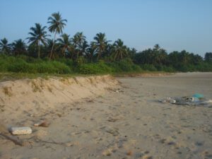
A.M. – Well, any human action on the landscape results in two types of impacts: reversible or irreversible. Now, the disappearance of the frontal dunes causes the beach to recede, making the coastline much more vulnerable to the action of the sea.
O.N. – So, in order to properly address the environmental status of our territory, we must qualify these matters, mustn’t we?
A.M. – For sure! Google Earth shows where Goa stands! Let’s, then, do a fly-by, say from our beaches to the Western Ghats, across the khazans that are our rice paddy fields. We will see the kind of impact that the different areas of the territory have suffered. For example, if a forest is destroyed, the system can be rejuvenated; and a contaminated river can be oxygenated; even khazans converted into a housing area is recoverable. But the destruction of the coast is almost always irreversible.
O.N. – What examples do you have of this in Goa?
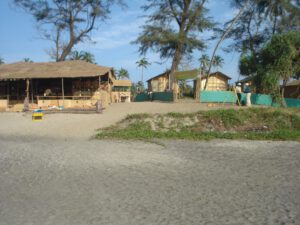
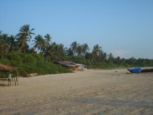
A.M. – Well, in Sinquerim and Candolim, the beach retreated due the impact of the River Princess ship that was stuck there for twelve long years! The dunes were flattened also to make place for hotels and residences. The fact is that the dunes do not get replenished easily; sometimes the sand takes decades to come back. Of course, to speed up the process, the beach can be nourished, by filling up the affected parts with new sand. This process also occurs naturally during the period after the monsoon, between September and March. For example, in Baga, Morjim and Querim, a sandy tip is formed. The tip is caused by the sand transported by the coastal current that enters the river or estuary, and is then pushed counterclockwise by the sea. Further north, the dunes disappeared to make way for shacks, with the exception of Mandrem, Morjim and Galgibaga…
O.N. – The case of Galgibaga, in the taluka of Canacona, is different, isn’t it?
A.M. – Yes. This area is protected by the Coastal Regulation Zone (CRZ) law, and is considered a breeding ground for turtles, one of the four sites in Goa. Hence, urban development in this place is completely forbidden. And thus the beach has remained well preserved. But on those dunes, there are small little houses that function as restaurants. The National Green Tribunal has ordered their demolition.
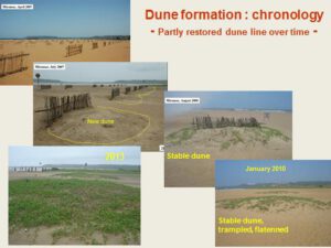
O.N. – As far as I know, the dune protection in Miramar was one of the first environmental campaigns that you undertook, in 2007, well over a decade ago…
A.M. – That’s right. I was part of the Goa Coastal Zone Management Authority, and am at present a member of the Goa Biodiversity Board. One of the projects we proposed was to save these frontal dunes. Some sites have been indicated where you can replicate that experience of dune reconstruction. Miramar beach is already being considered for this.
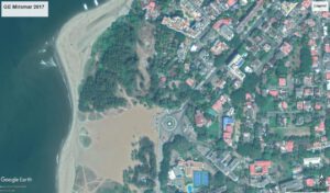
And talking of Miramar: here you find a semi-circular sand deposit, in the form of a sand bar, perhaps one of the few its kind in the world. It accretes and gets washed out, and then the sand comes back during the monsoon. It is an annual phenomenon and has been going on for centuries. The feast of the church of St. Lawrence, on the Sinquerim hilltop, from where you can see the silting, coincides with the opening of the sand bar…. I don’t know the connection.
O.N. – That was one reason why Albuquerque had to wait until the end of the monsoon to win Goa back… Here we see a connection between a natural phenomenon and a historical occurrence….!
A.M. – That’s right. There is that ‘tongue of sand’ at the site, now known as the Aguada sandbar. Here the navigation channel is very narrow and, after the monsoon, it opens up naturally. Unfortunately, the authorities are thinking of dredging the channel, and that’s going to be a real tragedy. Scientist C. S. Murthy has described the functioning of this area. The currents go south to north while on the other side they flow from north to south. On the coast, the currents run from south to north, from Caranzalem to Miramar; and from north to south, from Campal to Miramar. This process is responsible for the formation of the tongue of sand in Miramar. During the monsoon, when the waves caused by the winds from the west reach Miramar, they cause sand erosion; and later, when the good weather returns, the currents get normalized, helping to rejuvenate the beach. This has been an annual process noticed for decades.
O.N. – And does that protect the coast?
A.M. – Well, it was wrongly assumed that the coast would be protected with the construction of a barrier or wall made of large basalt stones brought perhaps from Maharashtra. But this wall has caused the beach to disappear and today we only have those stones left there. This human action on the beach has had consequences just in front of the old Medical School. The Campal stream flows out here. At this point a sandbar has emerged, blocking the passage of the said stream.
O.N. – By and large, is the ecology of the capital city at risk?
A.M. – The danger is not of very great proportions but it is also not something that can be ignored. For example, saline water enters and flows up to where the Fire Brigade is currently located. Despite this, there are many who have an interest in reducing the status of the stream to that of a nullah, a mere drain. The geological maps of the Survey of India of 1965 prove that there is movement of the tidal waters. Therefore, the stream is comes under the purview of special laws relating to the preservation of coastal zones. On the other hand, if it is reduced to the status of nullah, the said area will be outside the scope of those laws.
O.N. – There was destruction of the dunes when the area of Caranzalém was urbanized… What irreversible effects are we witnessing today?
A.M. – Well, in the 1990s the Caranzalém swamps began to disappear, which today are the largest urban area located in the wetlands in Goa. Before this, in the 1970s, the largest area that suffered destruction was where the bus terminus of the capital is located. Today, the high-rise buildings there have their foundations as though floating in the groundwater. These waters are now contaminated. All the wells in the city suburbs have no potable water – whereas I have a fresh-water well at my house in the village of Raia.
O.N. – And for that matter, what is your say on the Mandovi, which is the hope of salvation not only for the capital but also for the territory?
A.M. – It so happens that the neighbouring state Karnataka, where the Mandovi is born, has been trying to divert the water at the very source. The case is in court. Meanwhile, today, Mandovi’s condition is nowhere near the same as that of Delhi’s Yamuna or Bangalore’s Ulsoor Lake. It is less oxygenated but, fortunately, not only does the monsoon refresh the river but also its connection to the sea neutralizes all harmful influences.
O.N. – You have been a scientist at the National Institute of Oceanography… What is the relationship between oceanography and the ecology of the hinterland?
A.M. – Let me explain: The oceans are controlled by the tides twice a day. The water levels rise and fall. The same happens in rivers. In Goa, the impact of the sea is felt up to the remote village of Savoi Verem, in the taluka of Ponda, and up to the village of Macazana of the taluka of Salcete there is appreciable amplitude of tides and saline influx. So, the ocean is connected with the smallest stream. This is confirmed by mangroves, which indicate the presence of saline water. In fact, the area that goes from Cortalim to Macazana, passing through Curtorim and Rachol, has large mangrove swamps. The same can be said of the area between Carambolim and Agaçaim, passing through Azossim, Mandur and Neura.
O.N. – Which is the regulatory authority for wetlands?
A.M. – Well, it is interesting to note that all khazans belong to our Comunidades (agricultural communities). But presently the recently formed Wetland Authority of Goa is in charge. The khazans function as reserves of drinking water. Hence it is essential that our Comunidades are aware of the issues and assert themselves.
O.N. – It seems that the mangroves have helped to afforest the territory…
A.M. – That’s right. But this too has to be controlled because mangroves are “colonizers”. For example, in Panjim, a mangrove has appeared in an area that was traditionally a salt pan. Likewise, the floodplains at lower levels are now invaded by these trees; and this prevents farmers from cultivating the fields…. These mangroves have engulfed the Linhares Bridge from Panjim to Ribandar and are thus destroying the identity of the historic bridge. And to complicate matters further, there is a garbage treatment plant in the middle of the same mangrove lagoon. These are matters that call for attention.
O.N. – You are a recipient of the ‘Green Heroes’ award from TERI (Tata Energy and Resources Institute), New Delhi. You write regularly for the newspapers, popularizing many of the subjects we’ve talked about today… Is the level of public participation in these matters something that satisfies you?
A.M. – I’m neither satisfied nor frustrated. For 36 years I worked at the National Institute of Oceanography in Goa, a public funded organization. Salaries are paid by the Public Exchequer; hence my primary duty is to meet the needs of society in general and, in particular, to contribute to the conservation of nature.
Of course, public participation in these matters could have and should have been better…. We have the obligation to know the functioning of natural ecosystems: the functioning of the coast and the hills that are found in the hinterland. But it seems that today we suffer from information overload. There are many who do not read, there are others who read but do nothing, and only a few who do act proactively.
But the important thing is that to have proper planning and coordination between the authorities. To manage these issues, a cross-sectoral approach is indispensable. And there should be no politicking. The whole matter must be treated as a sacred cow: the mangroves, dunes, marshes, tidal areas, beaches are all sacred. They are exclusively under the responsibility of Coastal Regulation Zone I (CRZ I), but there have been deviations, there have been transgressions…
O.N. – You’ve travelled through Europe. What initiatives have you noticed?
A.M. – For example, in 2007, I visited the University of Algarve, as a fellow of Fundação Oriente. The sand dune systems there have been recreated. On the beach of Tavira, in a part of the marsh called Ria Formosa, there are now long dune areas; these have been artificially reconstituted but work naturally. Some wooden bridges have also been built that help visitors move to the beach without trampling the frontal dune. Faro beach is a good example of conservation of the fore dunes.
We have similar examples In France. The beach nourishment technique is employed for sand restoration purposes, and this controls erosion. Also erection of wooden fences blocks wind borne sand; and over time these sandy deposits become the frontal dunes.
That’s precisely what we propose for Miramar Beach. Well, it also helps to have plantations on the dunes: they help stabilize the dunes.
O.N. – It is obvious that much depends on the political will and public participation in safeguarding our heritage…
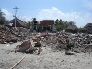
A.M. – Yes, there’s no doubt about that. I would be happy if the authorities and the general public were convinced of the great importance of the conservation of natural systems, in particular the coastal area, our beaches and the dunes. These are the first line of defence against the incursions of the sea. If we save the dunes, the population will be saved in the event of an attack from the sea. The tsunami of the year 2004, which devastated parts of Tamil Nadu, has already proven this theory right. I always say that the population was decimated not by the tsunami but by our recklessness in provoking the forces of nature, with construction of urban structures in inappropriate places. In this respect, our ancestors were more sensible. They respected nature and lived hand in hand with it. Thus, from Canacona to Pernem, they were always safe and sound.
O.N. – Well, it was a pleasure talking to you. Thank you for the panoramic view that you gave us on a topic of great importance to our beloved Goa. Thank you.
A.M. – Thank you! Thank you very much!
(First published in Revista da Casa de Goa, II Serie, N.º 6, Set.º-Out.º de 2020)
https://documentcloud.adobe.com/link/track?uri=urn:aaid:scds:US:80665fef-61a8-44bb-988a-e697ace84c22